
The Most Dangerous Stagecoach Ride in the World
by Dr Jon Solberg
As the morning’s first ray of sunshine crept over the horizon, our Jeeps’ shadows awoke, slowly appearing over the muddy waters of the Pecos River. We broke camp without speaking and sat down to enjoy a cup of coffee, looking westward and forward to our upcoming week of retracing the Butterfield Overland Mail Route. This seemed a fitting place to start the adventure, as in 1858, the time of the first westbound transcontinental stagecoach voyage, civilization, law, and order stopped here at the Pecos. Beyond its murky waters lay uncharted territory, opportunity, and the most vicious characters in the country.
My cell phone beeped with a text message and I wondered aloud, “Jake, do you suppose there’s any wildness left in the West, or have cell phones and pavement killed it?” Jake shook his head and slowly turned towards me with his classic, thousand-mile stare. “Jon, you’d better turn that thing off and keep your head on a swivel, we’re about to retrace the longest and most dangerous stagecoach ride in the history of the world.” With that, we finished our coffee, broke camp, and headed west across the Pecos.
Butterfield Stagecoach schedule. Click to enlarge.
The Butterfield Overland Mail Company
The 1850s were an exciting time in America. Between 1803 and 1845, the United States formally acquired all land west of the Mississippi River. California became a state in 1850, but was isolated by vast expanses of uncharted, uncivilized territory. At that time (this was 60 years before the completion of the Panama Canal), the only reliable mail and passenger service between New York and San Francisco was a 15,348-mile journey by ship around the tip of South America. But California was booming and its population cried for more efficient communication with the East Coast. Congress responded in 1857 by passing an overland mail bill. Soon, the United States Post Office Department accepted John Butterfield’s bid for “the conveyance of the entire letter mail from such point on the Mississippi River as the contractors may select, to San Francisco…for six years at a cost not exceeding $600,000 per annum for semi-weekly service.” Butterfield had already proven himself successful in the express business, but his newly formed Butterfield Overland Mail Company (OMC) and its soon-to-be 2,000 employees faced an enormous challenge: establish nearly 200 stage stations over 3,134 miles of uncharted territory, run the route twice weekly, and never, ever be late.

Llano Estacado near Guadalupe Peak, Texas.
The Llano Estacado
Waterman Ormsby, correspondent for the New York Heraldand OMC’s first through passenger, published handwritten accounts that were to guide much of our trip. From St. Louis to the Pecos River, his ride was fast and furious, with stage stops being short and well coordinated, allowing only enough time to switch the pulling teams. At the Pecos, however, the trail turns north and crosses the Llano Estacado, or Palisaded Plain, rising 10 feet per mile to the northwest and culminating at the base of 8,751 foot Guadalupe Peak, the highest point in Texas. General Randolph Marcy, on a scouting trip for the U.S. Army, described the Llano Estacado as a “treeless, desolate waste of uninhabitable solitude, which always has been and must continue uninhabited forever.” The route the Butterfield ultimately followed was marked in 1855 by Army topographer Captain John Pope, and it was challenging to say the least. It was so rough it required mules instead of horses, and at times the animals required physical beatings to achieve any forward progress. Ormsby lamented that the route from here was “full of stumps and bunches of weeds which made it by no means pleasant riding in the wagons, for the jolting was almost interminable and insufferable, and I frequently wished that Captain Pope could experience myride over his road.”
Starting at the Pecos, the stage was driven by Captain Henry Skillman, who was no stranger to frontier life. Ormsby described him as resembling “the Wandering Jew, with the exception that he carries several revolvers and bowie knives, dresses in buckskin, and has a sandy head of hair and beard.” From the Pecos to El Paso, Captain Skillman spent “four days on the box without a break, behind four wild mules over 306 miles of the most twisted, nearly waterless, rock-strewn, narrow passages on the entire Butterfield trail—an almost superhuman feat of stage-driving.”
I didn’t have Captain Skillman, but was traveling with Jake Quinones, friend and owner of New Mexico Backroads guide service. Jake grew up in the desert Southwest, cutting his teeth guiding vehicles on the Chile Challenge and working for Ted Turner on his ranch in northern New Mexico. No one knows the region like Jake, and he’s spent years fostering a working relationship with government agencies and private landowners; relationships that would in the coming miles gain us access into some of the country’s most scenic backcountry roads and hidden archaeological sites. Jake had arranged for us to stay in a beautifully secluded, private camp site that night and, once the cell phones were turned off, we were serenaded by coyotes as we enjoyed a sunset and twilight totally devoid of ambient lighting.

Polancio’s grave stone. Photo credit: Jake Quinones. Click photo to explore.
Polancio’s Grave
After a short backroads drive the following morning we arrived at Guadalupe Mountains State Park, home to the Pinery Station. The Pinery’s precariously tilted flat-rock and mud-mortar walls rise proudly from the hillside, as if it is still standing watch over the Llano Estacado, which sprawled out to he east as far as the eye can see. This was a favorable stop for the OMC due to its naturally occurring ponderosa pine, reliable spring water, and incredible view. Coincidently, it’s also a defendable position. The threat posed by the Apache Indians to workers and passengers cannot be understated. Just before Ormsby rolled through, the Apache had killed Jose Maria Polancio, infantry guide for the U.S. Army. He had gone out for a day of scouting and never returned. The following day his body was found, naked and shot full of arrows. Fellow soldiers removed the arrows, covered him with a buffalo robe, and gave him a proper burial; only to re-discovered him the following morning exhumed, stripped naked again, scalped, and re-shot with arrows. His weathered, limestone grave marker can still be seen not far from the state park boundary. Jake had acquired GPS coordinates, and after a short bushwhacking hike from the highway we found ourselves smack dab next to Polancio’s final resting place. We made a rubbing, dumped some whisky on the ground in his honor, and lightheartedly decided that it was a fine place to be buried…twice.

Entrance to Thorn’s Well. Private Land. Photo: Dr Jon Solberg
Sacred Land And Water
The next morning we followed the route through Guadalupe Pass and across an expansivev salt flat. Here, the gypsum and crystalline landscape gleamed with an almost heavenly white, appearing like a perfectly still and reflective freshwater lake, though we were miles and miles from any source water . From the salt flats it’s not far north to the New Mexico border and the Cornudas Mountains, where the Ormsby notes the “rocks or boulders are of red sandstone, and on the principal peak are of an oblong character, set with such remarkable regularity as to appear to be a work of art.” When we arrived at the former Cornudas Station we had lunch and waited behind a well maintained, barbed wire fence; Jake had arranged for us to meet the landowner.
It wasn’t long before a swirling dust cloud shrouded the arrival of a well-used truck. A door slammed and the driver emerged, appearing through the dust like a cowboy born a century too late. He tipped his hat and extended a hand, choosing his words carefully as he explained at length that this was sacred land, “not owned by me,but rather entrusted to me for my time on this earth,” he waxed. We must have measured up, and he eventually said, “Well, I’m not some god-damned park ranger, I’ve got cattle to take care of. Leave your Jeeps here and walk over to the mountain.” He spit onto the ground. “You’ll find what you’re looking for.” He offered no more directions, hints, or instructions, but simply turned and walked back to his truck, disappearing over the next hill in the same dusty cloud in which he appeared. We slid under the barbed wire fence and hurried towards the mountain as instructed. Finding a well-worn path, we followed it through the grass to a triangular hole between two rocks, just large enough to crawl through. Above the hole, THORNS WELL was etched into the stone. “You first,” said Jake.

Thorn’s Well.
I crouched down, crawled through, and waited. Jake emerged and stood up, brushing the dust from his pants. I offered him my canteen of drinking water. He took a swig and a drop rolled to the corner of his lip where it hung for a moment before falling to the dirt floor and vanishing. Just ahead was a well, capped with thick, weathered planking; it made me think of a wishing well from a Disney movie. I gripped the rusty and pitted iron ring handle and heaved the lid aside. Our noses were greeted with the sent of humid peat, a moist and earthy smell. I reached down and grabbed a small pebble, peered back into the inky blackness, and dropped it. One…two…three…splash. Wow! Here, deep inside the Cornudas Mountains lay the only thing that really mattered in the desert; liquid gold. We recalled historical accounts of the well being dry. “Can you imagine,” Jake pondered aloud, pausing only to take another pull from the canteen, “crossing all that desert and finding this well dry?” I shuddered at the thought. We spent the next hour climbing through a series of caves that lead away from the well, our path being illuminated only by thin rays of light that penetrated the precariously stacked boulders overhead.
During a brief break from the climbing, we took a break for water. The sound of it being swallowed seemed to echo off the cave walls and my heart pounded into my ears. I pulled from the canteen and missed a drop. It dribbled from my month, dripped to the ground, and I was overcome with guilt for wasting. When we emerged through a hole half way up the mountain, the last round portion of sun was disappearing over the horizon and I again offered Jake the canteen. He shook it, saw that little was left, and politely passed it back to me. “You have the last drop,” he said. We weren’t just traveling on the Butterfield, but experiencing it first hand.
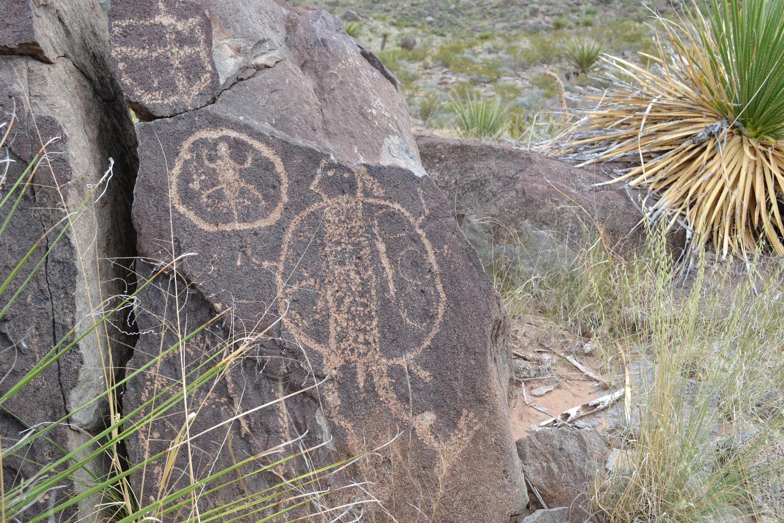
Petroglyphs on Alamo Mountain, courtesy of Wild Bill Luther, El Paso Archaeological Society.
The Apache Were Here First
A short drive from the Cornudas lies Alamo Mountain, another special place for Butterfield passengers. Ormsby noted its station was “well built of stone and adobe, among the best protected on the entire route.” It is also a special place for Bill Luther, long time member of the El Paso Archaeological Society. Bill’s been coming to Alamo Mountain for years to document and study its petroglyphs. As an airplane fanatic, river guide, and Purple Heart awarded Vietnam Veteran, it takes a lot to impress him, but he keeps coming back to Alamo. “Do you hear that rattlesnake?” he paused, allowing us to listen. “It’s a good thing there’s a doctor along, eh!” He slapped me on the shoulder and laughed aloud. Was it a snake? I didn’t hear anything. It was cold that morning and there was some frost on the ground, but that didn’t stop Jake from donning leather-toed hiking boots and me from reminding myself that most snake bites were dry anyway. We followed Bill from one petroglyph to another, stepping carefully and moving deliberately, listening to Bill’s stories as he told us of rock art, of the mountain, and of the Butterfield. Bill seemed equally interested in our interpretation of the petroglyphs, explaining that no one truly knows what they mean, only that they were important. He reminded us that the Apache were here first, and though the Butterfield is an important piece of U.S. history, it also symbolizes the demise of a magnificent culture. We had come to Alamo Mountain in search of the crumbling stage house ruins, but this quest suddenly seemed less important than the everlasting images chiseled in stone by the Apache. We never actually found the station ruins, but picked up a piece of trash or two on our way out and left the rattlesnakes alone; trying to leave this sacred landmark in better condition than we found it.
As Ormsby traveled west of Alamo Mountain and towards El Paso, he remarked the road was “excellent, being a rolling plain with the exception of a very steep hill near the Sierra Alto, down which I much feared we could not descend into safety; but our driver seemed to know every stone and we whirled along on the very brink of the precipices with perfect safety, though the night was quite dark.” Descending into the Rio Grande Valley, he was delighted by the “aroma of the fruit and herbs…most grateful after so long and dreary a ride over the desert, and at that moment, I could have endorsed all the encomiums on the fertile valley of the Rio Grande.” At the time, El Paso’s OMC station was the biggest building in town and the largest on the entire route. While we couldn’t pay homage at the old mail station itself, we did stop to withdraw some money at the Wells Fargo Plaza, currently the tallest building in town. Interestingly, it was Wells Fargo that financially backed much of Butterfield’s investment. They eventually acquired OMC along with all other major western stage lines. The rest is history, as the saying goes, and the iconic red and gold stagecoach has remained the undisputed symbol of the financial giant ever since.
A New Route
Not long after Ormsby’s trip westward, the Butterfield was moved farther south to deliver better mail service to three military forts and to take advantage of more readily available water along the Rio Grande. At El Paso, the Butterfield’s halfway point, we turned east and picked up the 1860 trail of Reverend William Tallack, who chronicled his 1860 through-journey while traveling west to east. Tallack found the Rio Grande Valley full of “maize, wheat, sugar-cane, and sunflowers. Large blue cranes and wild geese were numerous, especially on the banks of the river and its tributary streams, whose overflowing obliged us to take several lengthy circuits.” Today, El Paso’s Rio Grande is a figment of its former self, nothing more than a dry arroyo for most of the year. This, along with a 20-foot-high steel fence along the border, appeared to us as more of a socioeconomic barrier between El Paso’s towering downtown and the ragged, dirt-filled streets of its sister city to the south, Juarez, Mexico.
The Past Lives On Through Ole Sag
East of El Paso we met up with another of Jake’s interesting acquaintances, Sag-Ashus (a pen name). Ole Sag, as he refers to himself in his weekly newspaper column, has made his home in Rio Grande Valley for 85 years; his family was there long before. We followed him for an entire day, weaving back and forth on gravel roads and stopping frequently to listen to his narrations. “I grew up in a house right over there, not a stone’s throw from the old Fort Quitman,” he explained. “My dad never left the house without a pistol because Pancho Villa’s army was still roaming around, terrorizing and looting.” After several stops, Ole Sag got out and surprised us by shuffling out across the desert at an alarming pace. We followed in hot pursuit around a corral, down an arroyo and up the other side, all without him missing a single step or looking back to check on us. “Well, here it is,” he said without raising a finger. Puzzled, I questioned him. “The Butterfield,” he said, “isn’t that why you two boys called me? You’re standing in it!” Ole Sag was sure of himself. His family had been in the area a long time, and the older folks told him the old Butterfield wagon route went right behind his childhood one-room, rock-walled school house; which we could see not 50 yards from where we stood.
There was no reason not to believe him. He continued, “The Butterfield ran right here. You’re standing in it. Can’t you hear it?” “Hear what?” I asked. “The Butterfield! If you listen real close, can’t you hear the hooves pound the ground, the wagon wheels spinning and bumping over the rocks, the conductor blowing his whistle? The view from here is the same view the passengers had from their windows. The Butterfield came round that mountain and down the arroyo.” He paused, grabbed a stick, and began drawing a map into the dirt. He dragged a big X. “You’re looking at it. Look, there are the tracks right there.” He pointed the stick. By golly, he was right, leading away from the very place we stood were what looked like wagon tracks; about the same width as a stagecoach, worn down into the ground and filled in with sand and pebbles of a different color, size, and consistency. “Those lines in the dirt were there when I was five years old, and they look the same today. They’re Butterfield tracks!”
Four wheel drive up Quitman pass.
We returned to the Jeeps, where he gave us directions to Quitman Pass, detailing how to find more Indian petroglyphs and Butterfield tracks, and warning us that we’d need four-wheel drive. “I’ll drive around and meet you on the other side,” he promised. We were off, and sure enough, Ole Sag was right: we needed four-wheel drive andwe found petroglyphs and names dating back to the 1800s, possibly beyond. Several hours later we arrived at the designated rendezvous point and Ole Sag was there waiting for us; he’d driven 50 miles around the mountain. It was an incredibly educational day, and Jake and I were as humbled by Ole Sag’s generosity as we were impressed by his knowledge and enthusiasm. Through him, the past lives on in our hearts and in the hearts of his devout readers in the Hudspeth County Herald. Please check it out online and leave a comment. Tell him Jake and Jon sent you.
Time To Kill
With time to kill before our next scheduled meeting we headed to Ft. Davis, a splendid and living example of a frontier military stronghold. In operation from 1854 to 1891, its commission was to protected emigrants, mail coaches, and freight wagons traveling the San Antonio-El Paso Road. Perfectly situated inside a canyon and flanked on three sides by sheer rock walls, Ft. Davis was positioned for defense. Its restored buildings and ruins are an accessible and educational stop for anyone traveling in these parts.
As we left the fort, Jake crested a hill in his Jeep and pulled over just past to two men standing alongside a pair of Harley Davidson motorcycles. I pulled up behind Jake and looked in my rearview mirror, trying to determine if they needed help. One of them wore a half-faced skull bandana and walked towards us. BANG! His fist collided with my passenger door as he passed, and I jumped with fright, unsure if it was a gesture of friendship or aggression. Jake rolled down his window and I kept my Jeep in Drive, ready to press the gas pedal and smear Mr. Skull’s guts all over the side of Jake’s Jeep if the situation deteriorated. They were speaking in Spanish when he suddenly he stepped back and opened Jake’s passenger door. I mentally prepared myself to hit the gas when he stepped back, slapped Jake’s roof, slammed the door, and walked back towards his motorcycle, not acknowledging me in the slightest.
Jake pulled out onto the highway and I followed, still completely mystified. Eventually he pulled over, exited his Jeep, and spread a map on the hood. “What was that all about?” I asked. “That guy recognized my Jeep from my website and wanted to check out my custom interior sleeping platform,” Jake calmly replied.“He’s a hunting guide and he said we aren’t going to find any backroads out here because it’s all private land. The only open gravel road of any length was through El Pinto Canyon, but he recommended avoiding it as it’s frequented by drug runners and such.” “But it’s scenic?” I asked to clarify. “Very scenic,” Jake replied. That settled it, we were off to search for El Pinto Canyon Road.
We found it all right, trailing southwest of Marfa and heading downhill all the way to Mexico. El Pinto Canyon Road is perfect for drug runners and outlaws. If the engine quits or you run out of gas, just throw ‘er in neutral and coast all the way to the Rio Grande. Hit it with enough momentum and you could skip the car across to the other side—instant impunity. Thankfully, the El Pinto was deserted that afternoon, and we were free to stop and take photos while enjoying a late afternoon breeze. At the bottom we turned and drove along the river, noticing a plethora of foot tracks suspiciously crossing the river and crossing our track at a 90-degree angle
Veering off the gravel and towards the river, we followed a two-track through the grass. A sheer rock wall began to rise up on the north side, which left us no option but to go but straight ahead or into the Rio Grande itself. We continued along for some time before Jake stopped. Getting out to investigate I found that the road abruptly dropped two feet down an embankment and into the Rio Grande. “Why would the trail just suddenly stop?” I asked. “It doesn’t,” Jake responded, pointing across the river. Just 50 feet in front of us the road emerged onto the adjacent shore—Mexico! There was no fence, no checkpoint.
For no particular reason, I reached under my front bumper to check the new sway bar end links I had installed before the trip. One of the nuts had come almost completely off! “Of course I didn’t torque it to specs!” I cut Jake off and ran around back to fetch my tool roll, selected the appropriate socket, and quickly spun the nut down to where it should have snugged. “It’s stripped,” I cursed.
There was no one else around and the sun was setting. “Jon, we need to get out of here. Someone could walk right out of those bushes and put a gun to our heads, drive the Jeeps across the river, and we’d never be seen again.” Jake didn’t paint a pretty picture. “Oh man, you’re right,” I exclaimed, and my desire to troubleshoot the problem vanished into thin air; which is what I imagined might happen to us if we didn’t get out of there quickly. Without room to turn the Jeeps around, we backed out the entire way, flanked by the rock wall on one side and the river on the other. Thankfully, we didn’t meet any headlights until we were back on the highway.
When It’s Your Land, You Make Your Own Rules
The following day, Jake had arranged another meeting with a local rancher. We met at a derelict windmill site and followed his white, Ford King Ranch edition pickup east on a gravel track while the summit of Aguilla Peak looming in the distance. Rounding a corner, we eased up a hill past two Mexican vaqueros on horseback and arrived in front of a ranch house that had been hidden from our view.

King Ranch, as we’ll refer to him because he prefers to remain anonymous, walked over and asked us to move our Jeeps onto his driveway. “Pretty recently the Border Patrol chased a pickup full of outlaws right through here. Woulda’ ran right into my truck if they hadn’t called ahead to warn me.” “What happened?” Jake asked. “Well, the Border Patrol chased them through my yard and up my mountain until the outlaws spun out. Three of ‘em got out and ran, but the other hid behind a bush and started a shootin’. The agents shot him three times in the chest and then had him airlifted to the hospital.” Jake and I looked at each other, trying to guess if this was a true story or not. But it was all right there in the Hudspeth County Herald. December 19, 2014: “Three arrested after chase, gunfight in Southern Hudspeth County.”
We stood under the porch while King Ranch rocked in a chair, shelling pecans with his grandpa’s old pocketknife and occasionally looking up over his wire rimmed glasses to see if we were actually listening. He must have been in his 80s, and he explained that he was literally born “on” the Rio Grande: whether in a covered wagon, beside a tree, or on which side of the border he wouldn’t say. When he was a child his dad rescued a local Mexican boy that had been tied up outside a ranch house after being beaten by his father. They cut the child loose, had words with boy’s father, and took the boy home to raise him as part of the family. Jake and I learned that Red Light Draw, which we passed just before reaching the Mexican vaqueros, was named after a former homestead-era rancher who hoisted a red lantern to the top of his wellhead each night in case travelers were lost and in need of water. He figured they would see his light, come to him, and be made refreshed. Jake and I marveled at the incredible hospitality displayed by those who make their home in these inhospitable parts.
Out the porch window was an unforgettable scene: a mule deer grazed near the road as the early evening sun cast the faintest hint of orange over the valley. I commented on the remarkably tall grass and that it seemed out of place in the desert. King Ranch went on, “My grandpa used to graze 1,000 head of cattle on the old family ranch (a different location). Today it will barely support 100 cattle. This whole area is overgrazed. When Cortez came through in the 1500s he said it was one large sea of grass. Now, it’s sagebrush and scraggily mesquite. This ranch is different though. It’s private, and I manage it myself, and do a pretty damn good job too. I don’t overgraze. We control erosion. My land’s in good shape, even though we’re in the middle of a drought.” He looked up at us again. “This mountain has a ton of game: mule deer, aoudad, mountain lion, animals you may not see on public land. Let me show you my living room.” He stopped shelling and led us to his living room, which was filled with mounted game of all varieties taken right on his own land, one of them “from 534 yards with a .223. Now that’s some damn good shootin’” he complimented himself. “When it’s your land, you make your own rules, take care of it how you see fit. Take pride in it. When it’s not your land you overgraze and take as much as you can get, like on public lands.” He paused again, possibly for effect. “So, you boys are going to stay on my mountain, is that right?”

Aguilla Peak
In a sense, we had gained the keys to his property for no logical reason. We hadn’t paid him and he didn’t owe us anything. We were just two curious and courteous chaps, out to learn a little history and enjoy Mother Nature. With Jake in the lead we departed the ranch house, rounded a corner, went through an arroyo, and started up Aguilla Peak. This was without a doubt the most incredible road I’ve driven. Despite Jake’s years of guiding in the Southwest, I think he was equally in awe. We were soon in four-wheel drive and eventually in four low. When we reached an incline that would permit the Jeeps to go no further without spinning a front and back tire, we engaged the rear lockers. Approaching a saddle near the top, my Jeep would not make the tight switchback corner. I started slipping backwards and I pressed the brake pedal with all my might; the tires skidding closer and closer to the edge. There I was, alone, in the dark on a private 10,000-acre ranch without cell phone reception, and skidding toward an abyss of the nearly 2,500 vertical feet we had ascended in just two miles; the edge of the very Earth itself. My foot was trembling on the brake pedal when Jake shouted down at me from around the switchback, “Cramp the wheel to the left and use both lockers!” Jake’s experience as a guide was showing through. I clicked in the front locker, eased my left foot off the brake pedal as I applied slight pressure to the gas with my right. All four tires began rotating slowly, scratching and clawing at the rocky surface with a slow, grating sound, pulling the front of the Jeep up and around the switchback. We stopped near the top, speechless.
Anguilla Peak with view to the south, into Mexico.
We rolled our sleeping bags out between the Jeeps in the middle of the road, as there was literally no room on either side. We set our camp chairs next to the bags and sat down to reflect over an ice-cold beer. I thought about the view of my hometown, from atop a local mountain, its city lights twinkling below with a starless sky above. But this night was different. The ground below was the inky blackness, like the black you see when you stare down into the ocean at night, and the sky was ablaze with what looked like an endless city scape of street lights, flickering and broken only occasionally by the tail of a shooting star or the navigation lights from passing jet airliner.
What started as a simple goal to drive the Butterfield Overland Mail route and photograph as many of the ruins as possible had culminated high above the desert plateau, on Aguilla Peak. We recalled the people who lived and worked here: the rancher and his “duty” to care for the land, the archaeologist and his passion for an extinct culture, Ole Sag and his weekly newspaper columns, and our host this night and his willingness to open the gates for us simply because we’d been interested enough to ask. They are the main characters; they are what made this adventure special. The Butterfield Overland Mail route was then and still is a romantic high point in in our country’s history, and high on Aguilla Peak, as this chapter came to a most dramatic close. We turned our thoughts and sights westward, towards New Mexico, Arizona, and California, to the second half of the most dangerous and interesting stagecoach ride in the world.

One lock is not enough.
Retracing the West Texas Butterfield Overland Route
A note from NMBR Guide, Jake Quinones
“Some of Texas’ most magnificent backcountry is hidden away behind locked gates, accessible only by privately owned land and backroads. Land access will provide adventurists more hardship than the venomous snakes, flash floods, and borderland bandits that West Texas is known for, as over 90% of the state is private property. Before setting off for the banks of the Pecos River, map in hand, your journey will require a bit of research, a few phone calls and careful planning. Pick up 900 Miles On the Butterfield Trail by A.C. Greene and The Butterfield Overland Mail by Waterman L. Ormsby, which contain the history, maps, and geographical information of the Butterfield Trail. Once you have an understanding of the Butterfield Trail’s two [West Texas] stage routes and the surrounding terrain, build your own retrace. Use the stage stops as your guiding stars; their names still dot the map with springs, canyons, wells and peaks named after them. West Texas’s county and state maintained backroads will provide the best odds at accessing the Butterfield Trail, start with these roads first.
The best road information is not found on maps or peak bagger sites, you will need to dig deeper. Call local county and state road department offices and inquire about the best way to get though your areas of interest. Make sure you are friendly, not too assertive and state your intensions—with a little luck and a charming persona you will receive invaluable information that would have required fieldwork otherwise. If you suspect a locked gate may curse your path or want to avert a trespassing issue, log on to http://www.glo.texas.gov/and find out who owns the land you desire to cross. If you can’t track down the land owner through county records, call that resourceful county clerk back and ask them one last favor. Provide them legal description of a tract of land under the PLSS and [in most cases] they will provide you with landowner contact information. If you get this deep in researching and planning your Butterfield Route retrace, the bounty may pay twice on your efforts. Who knows, you may talk your way to the top of Aguila Peak or find yourself sitting in the hidden warm springs of the Chispa Mountains.

Jake Quinones, New Mexico Backroads. Visit NMBR by clicking the photo.
Before you go: Since drug and human trafficking are common in these lonely parts, you may arouse the suspicion local law enforcement while traversing the backroads of West Texas—especially if your vehicle is highly modified. Don’t be surprised if you have a drone circling your camp by night or get stopped by a small Calvary of federal agents. When dealing with law enforcement, make sure you are forthright and describe your travel plans in detail if asked. If by some lucky chance you are granted access [by the owner] onto private land, make sure you have a small gift [on hand] to give them. Ask them about their livelihood, family history and [mostly] just listen—some incredible stories may be told. As for the basics, have a plan, go prepared, stay aware of your surroundings, and respect land ownership rights. ¡Buena suerte mi amigo!